Sunrise and sunset times in Tikota
EditCheck out today's and tomorrow's sunrise and sunset times in Tikota, as well as the whole calendar for October 2026.
Today
October 23, 2026. Current time: 2:30:20 am

Night ends at 5:10 am5:09:56 am
Start of astronomical twilight: the Sun is 18° below the horizon and the sky begins to brighten, too faintly to notice in a city.·First light at 6:01 am6:00:39 am
Dawn, the start of civil twilight: the Sun is 6° below the horizon, and there is enough light to be outdoors without artificial light.
Sunrise time: 6:22:38 amWhen the top edge of the Sun appears over a flat, clear horizon. Behind hills, mountains or buildings the Sun appears a few minutes later (or more in a valley).

Sunset time: 6:01:37 pmWhen the top edge of the Sun disappears below a flat, clear horizon. Behind hills, mountains or buildings the Sun disappears a few minutes earlier (or more in a valley).
Dark at 6:24 pm6:23:36 pm
Dusk, the end of civil twilight: the Sun reaches 6° below the horizon, and from then on artificial light is needed outdoors.·Night at 7:14 pm7:14:19 pm
End of astronomical twilight: the Sun is 18° below the horizon and the sky is dark enough to see the faintest stars. In a city it looks dark sooner.
Sun position chart
Now · Sun altitude: -56.13° (below the horizon) · Azimuth: 85.2° (E)
Daylight Golden Hour Dawn & dusk (civil twilight) Night
Day length: 11 hours, 38 minutes
3 hours, 52 minutes left until today's sunrise in Tikota
 Moonset: 3:31 am
 Moonrise: 3:58 pmMoon phase: 🌔 Waxing Gibbous (87%)🌕 Full moon: Oct 26 at 9:41 am · 🌑 New moon: Nov 9 at 12:32 pm
Tomorrow
October 24, 2026
Night ends at 5:10 am5:10:10 am
Start of astronomical twilight: the Sun is 18° below the horizon and the sky begins to brighten, too faintly to notice in a city.·First light at 6:01 am6:00:55 am
Dawn, the start of civil twilight: the Sun is 6° below the horizon, and there is enough light to be outdoors without artificial light.
Sunrise time: 6:22:56 amWhen the top edge of the Sun appears over a flat, clear horizon. Behind hills, mountains or buildings the Sun appears a few minutes later (or more in a valley).
Sunset time: 6:01:03 pmWhen the top edge of the Sun disappears below a flat, clear horizon. Behind hills, mountains or buildings the Sun disappears a few minutes earlier (or more in a valley).
Dark at 6:23 pm6:23:04 pm
Dusk, the end of civil twilight: the Sun reaches 6° below the horizon, and from then on artificial light is needed outdoors.·Night at 7:14 pm7:13:49 pm
End of astronomical twilight: the Sun is 18° below the horizon and the sky is dark enough to see the faintest stars. In a city it looks dark sooner.
Day length: 11 hours, 38 minutes
Tomorrow will be 1 minute shorter than today in Tikota
Moonset: 4:24 am Moonrise: 4:36 pmMoon phase: 🌔 Waxing Gibbous (97%)
- Tikota, Karnataka
- Latitude: 16.842991 (North)
- Longitude: 75.521263 (East)
- Time zone: India Standard Time (IST, UTC+5:30)
Shortest day in Tikota, Karnataka
The shortest day of the year will be in 1 month and 29 days, during the winter solstice on December 22, 2026, with a daylight length of 11 hours, 7 minutes.Longest day in Tikota, Karnataka
The longest day of the year was around 4 months ago, during the summer solstice on June 21, 2026, with a daylight length of 13 hours, 8 minutes.



October 2026 - Tikota, Karnataka - Sunrise and sunset calendar
Sunrise and sunset times, civil twilight start and end times as well as solar noon, and day length for every day of October in Tikota.
All times are in Tikota's time: India Standard Time (IST, UTC+5:30).
The day length shortens by 27 minutes over the course of October 2026 in Tikota, Karnataka - from 11 hours, 59 minutes on the first day to 11 hours, 32 minutes on the last day.
| Day | First LightStart of civil twilight: the Sun is 6° below the horizon, and there is enough light to be outdoors without artificial light. | SunriseWhen the top edge of the Sun appears over a flat, clear horizon. Behind hills, mountains or buildings the Sun appears a few minutes later (or more in a valley). | Sunrise Variation |
SunsetWhen the top edge of the Sun disappears below a flat, clear horizon. Behind hills, mountains or buildings the Sun disappears a few minutes earlier (or more in a valley). | Sunset Variation |
Last LightEnd of civil twilight: the Sun reaches 6° below the horizon, and from then on artificial light is needed outdoors. | Day Length | Day Length Variation | Solar NoonTime of day when the sun reaches its highest point in the sky. | Max Sun Altitude | Nautical Twilight Start | Nautical Twilight End | Astronomical Twilight Start | Astronomical Twilight End | Night LengthCalculated from this day's sunset to the next day's sunrise. | Moon phase | Solar Midnight | Sun DeclinationThe latitude where the Sun is directly overhead at solar noon (the Sun's declination). It moves between the two tropics through the year. |
|---|---|---|---|---|---|---|---|---|---|---|---|---|---|---|---|---|---|---|
| Thu, Oct 1 | Twilight startStart of civil twilight: the Sun is 6° below the horizon, and there is enough light to be outdoors without artificial light.5:56:25 am | 6:18:02 am | +8s | 6:17:03 pm | -47s | Twilight endEnd of civil twilight: the Sun reaches 6° below the horizon, and from then on artificial light is needed outdoors.6:38:39 pm | 11h 59m 1s | -56s | Solar noonTime of day when the sun reaches its highest point in the sky.12:17:59 pm | 69.94° | 5:31:21 am | 7:03:43 pm | 5:06:15 am | 7:28:47 pm | Night lengthCalculated from this day's sunset to the next day's sunrise.12h 1m 8s | 🌖 (70%)Waning Gibbous: 70% illuminated at midnight, at the end of the day | 12:18:09 am | 3.2° S |
| Fri, Oct 2 | 5:56:34 am | 6:18:11 am | +9s | 6:16:15 pm | -48s | 6:37:52 pm | 11h 58m 4s | -56s | 12:17:39 pm | 69.55° | 5:31:29 am | 7:02:56 pm | 5:06:24 am | 7:28:00 pm | 12h 2m 5s | 🌖 (59%)Waning Gibbous: 59% illuminated at midnight, at the end of the day | 12:17:49 am | 3.6° S |
| Sat, Oct 3 | 5:56:42 am | 6:18:20 am | +9s | 6:15:28 pm | -47s | 6:37:05 pm | 11h 57m 8s | -56s | 12:17:20 pm | 69.16° | 5:31:37 am | 7:02:10 pm | 5:06:32 am | 7:27:13 pm | 12h 3m 1s | 🌗 (48%) Last quarter at 6:55 pmLast quarter at 6:55 pm. At midnight, at the end of the day: 48% illuminated |
12:17:30 am | 4.0° S |
| Sun, Oct 4 | 5:56:51 am | 6:18:29 am | +9s | 6:14:41 pm | -47s | 6:36:19 pm | 11h 56m 12s | -56s | 12:17:01 pm | 68.78° | 5:31:46 am | 7:01:24 pm | 5:06:41 am | 7:26:28 pm | 12h 3m 58s | 🌘 (36%)Waning Crescent: 36% illuminated at midnight, at the end of the day | 12:17:11 am | 4.4° S |
| Mon, Oct 5 | 5:57:00 am | 6:18:39 am | +10s | 6:13:55 pm | -46s | 6:35:33 pm | 11h 55m 16s | -56s | 12:16:42 pm | 68.39° | 5:31:54 am | 7:00:38 pm | 5:06:49 am | 7:25:42 pm | 12h 4m 54s | 🌘 (26%)Waning Crescent: 26% illuminated at midnight, at the end of the day | 12:16:51 am | 4.8° S |
| Tue, Oct 6 | 5:57:09 am | 6:18:49 am | +10s | 6:13:09 pm | -46s | 6:34:48 pm | 11h 54m 20s | -56s | 12:16:24 pm | 68.01° | 5:32:03 am | 6:59:54 pm | 5:06:58 am | 7:24:58 pm | 12h 5m 50s | 🌘 (17%)Waning Crescent: 17% illuminated at midnight, at the end of the day | 12:16:33 am | 5.1° S |
| Wed, Oct 7 | 5:57:19 am | 6:18:59 am | +10s | 6:12:24 pm | -45s | 6:34:03 pm | 11h 53m 25s | -56s | 12:16:06 pm | 67.63° | 5:32:12 am | 6:59:10 pm | 5:07:07 am | 7:24:14 pm | 12h 6m 45s | 🌘 (9%)Waning Crescent: 9% illuminated at midnight, at the end of the day | 12:16:15 am | 5.5° S |
| Thu, Oct 8 | 5:57:29 am | 6:19:09 am | +10s | 6:11:39 pm | -45s | 6:33:19 pm | 11h 52m 30s | -56s | 12:15:48 pm | 67.24° | 5:32:21 am | 6:58:26 pm | 5:07:16 am | 7:23:31 pm | 12h 7m 41s | 🌘 (4%)Waning Crescent: 4% illuminated at midnight, at the end of the day | 12:15:57 am | 5.9° S |
| Fri, Oct 9 | 5:57:39 am | 6:19:20 am | +11s | 6:10:54 pm | -45s | 6:32:36 pm | 11h 51m 34s | -55s | 12:15:31 pm | 66.86° | 5:32:31 am | 6:57:43 pm | 5:07:25 am | 7:22:48 pm | 12h 8m 38s | 🌘 (1%)Waning Crescent: 1% illuminated at midnight, at the end of the day | 12:15:40 am | 6.3° S |
| Sat, Oct 10 | 5:57:49 am | 6:19:32 am | +12s | 6:10:10 pm | -44s | 6:31:52 pm | 11h 50m 38s | -55s | 12:15:14 pm | 66.48° | 5:32:40 am | 6:57:01 pm | 5:07:34 am | 7:22:06 pm | 12h 9m 33s | 🌑 (0.1%) New moon at 9:20 pmNew moon at 9:20 pm. At midnight, at the end of the day: 0.1% illuminated |
12:15:22 am | 6.7° S |
| Sun, Oct 11 | 5:58:00 am | 6:19:43 am | +11s | 6:09:27 pm | -43s | 6:31:10 pm | 11h 49m 44s | -55s | 12:14:58 pm | 66.11° | 5:32:50 am | 6:56:19 pm | 5:07:43 am | 7:21:25 pm | 12h 10m 28s | 🌒 (1%)Waxing Crescent: 1% illuminated at midnight, at the end of the day | 12:15:06 am | 7.1° S |
| Mon, Oct 12 | 5:58:11 am | 6:19:55 am | +12s | 6:08:44 pm | -43s | 6:30:28 pm | 11h 48m 49s | -55s | 12:14:42 pm | 65.73° | 5:33:00 am | 6:55:38 pm | 5:07:53 am | 7:20:45 pm | 12h 11m 24s | 🌒 (5%)Waxing Crescent: 5% illuminated at midnight, at the end of the day | 12:14:50 am | 7.4° S |
| Tue, Oct 13 | 5:58:22 am | 6:20:08 am | +13s | 6:08:02 pm | -42s | 6:29:47 pm | 11h 47m 54s | -55s | 12:14:26 pm | 65.36° | 5:33:11 am | 6:54:58 pm | 5:08:03 am | 7:20:05 pm | 12h 12m 19s | 🌒 (10%)Waxing Crescent: 10% illuminated at midnight, at the end of the day | 12:14:34 am | 7.8° S |
| Wed, Oct 14 | 5:58:34 am | 6:20:21 am | +13s | 6:07:20 pm | -42s | 6:29:07 pm | 11h 46m 59s | -55s | 12:14:11 pm | 64.98° | 5:33:21 am | 6:54:19 pm | 5:08:13 am | 7:19:27 pm | 12h 13m 14s | 🌒 (16%)Waxing Crescent: 16% illuminated at midnight, at the end of the day | 12:14:18 am | 8.2° S |
| Thu, Oct 15 | 5:58:46 am | 6:20:34 am | +13s | 6:06:39 pm | -41s | 6:28:27 pm | 11h 46m 5s | -54s | 12:13:57 pm | 64.61° | 5:33:32 am | 6:53:40 pm | 5:08:23 am | 7:18:49 pm | 12h 14m 9s | 🌒 (24%)Waxing Crescent: 24% illuminated at midnight, at the end of the day | 12:14:04 am | 8.5° S |
| Fri, Oct 16 | 5:58:59 am | 6:20:48 am | +14s | 6:05:59 pm | -40s | 6:27:48 pm | 11h 45m 11s | -54s | 12:13:43 pm | 64.24° | 5:33:44 am | 6:53:02 pm | 5:08:34 am | 7:18:12 pm | 12h 15m 3s | 🌒 (33%)Waxing Crescent: 33% illuminated at midnight, at the end of the day | 12:13:50 am | 8.9° S |
| Sat, Oct 17 | 5:59:12 am | 6:21:02 am | +14s | 6:05:19 pm | -40s | 6:27:09 pm | 11h 44m 17s | -54s | 12:13:30 pm | 63.88° | 5:33:56 am | 6:52:25 pm | 5:08:45 am | 7:17:36 pm | 12h 15m 58s | 🌒 (42%)Waxing Crescent: 42% illuminated at midnight, at the end of the day | 12:13:37 am | 9.3° S |
| Sun, Oct 18 | 5:59:25 am | 6:21:17 am | +15s | 6:04:40 pm | -39s | 6:26:32 pm | 11h 43m 23s | -54s | 12:13:17 pm | 63.51° | 5:34:08 am | 6:51:49 pm | 5:08:56 am | 7:17:01 pm | 12h 16m 52s | 🌓 (51%) First quarter at 9:42 pmFirst quarter at 9:42 pm. At midnight, at the end of the day: 51% illuminated |
12:13:23 am | 9.6° S |
| Mon, Oct 19 | 5:59:39 am | 6:21:32 am | +15s | 6:04:02 pm | -38s | 6:25:55 pm | 11h 42m 30s | -53s | 12:13:05 pm | 63.15° | 5:34:20 am | 6:51:13 pm | 5:09:07 am | 7:16:26 pm | 12h 17m 46s | 🌔 (61%)Waxing Gibbous: 61% illuminated at midnight, at the end of the day | 12:13:11 am | 10.0° S |
| Tue, Oct 20 | 5:59:53 am | 6:21:48 am | +16s | 6:03:24 pm | -38s | 6:25:19 pm | 11h 41m 36s | -53s | 12:12:53 pm | 62.79° | 5:34:33 am | 6:50:39 pm | 5:09:19 am | 7:15:53 pm | 12h 18m 40s | 🌔 (70%)Waxing Gibbous: 70% illuminated at midnight, at the end of the day | 12:12:58 am | 10.4° S |
| Wed, Oct 21 | 6:00:08 am | 6:22:04 am | +16s | 6:02:48 pm | -36s | 6:24:44 pm | 11h 40m 44s | -53s | 12:12:43 pm | 62.43° | 5:34:46 am | 6:50:05 pm | 5:09:31 am | 7:15:21 pm | 12h 19m 33s | 🌔 (79%)Waxing Gibbous: 79% illuminated at midnight, at the end of the day | 12:12:49 am | 10.7° S |
| Thu, Oct 22 | 6:00:23 am | 6:22:21 am | +17s | 6:02:12 pm | -36s | 6:24:10 pm | 11h 39m 51s | -53s | 12:12:32 pm | 62.08° | 5:35:00 am | 6:49:33 pm | 5:09:43 am | 7:14:49 pm | 12h 20m 26s | 🌔 (86%)Waxing Gibbous: 86% illuminated at midnight, at the end of the day | 12:12:37 am | 11.1° S |
| Fri, Oct 23 | 6:00:39 am | 6:22:38 am | +17s | 6:01:37 pm | -35s | 6:23:36 pm | 11h 38m 59s | -52s | 12:12:23 pm | 61.73° | 5:35:14 am | 6:49:01 pm | 5:09:56 am | 7:14:19 pm | 12h 21m 19s | 🌔 (93%)Waxing Gibbous: 93% illuminated at midnight, at the end of the day | 12:12:28 am | 11.4° S |
| Sat, Oct 24 | 6:00:55 am | 6:22:56 am | +18s | 6:01:03 pm | -34s | 6:23:04 pm | 11h 38m 7s | -52s | 12:12:14 pm | 61.38° | 5:35:29 am | 6:48:30 pm | 5:10:10 am | 7:13:49 pm | 12h 22m 12s | 🌔 (97%)Waxing Gibbous: 97% illuminated at midnight, at the end of the day | 12:12:18 am | 11.8° S |
| Sun, Oct 25 | 6:01:12 am | 6:23:15 am | +19s | 6:00:29 pm | -34s | 6:22:32 pm | 11h 37m 14s | -52s | 12:12:06 pm | 61.03° | 5:35:44 am | 6:48:00 pm | 5:10:23 am | 7:13:21 pm | 12h 23m 4s | 🌔 (99.6%)Waxing Gibbous: 99.6% illuminated at midnight, at the end of the day | 12:12:10 am | 12.1° S |
| Mon, Oct 26 | 6:01:29 am | 6:23:33 am | +18s | 5:59:57 pm | -32s | 6:22:02 pm | 11h 36m 24s | -51s | 12:11:58 pm | 60.69° | 5:35:59 am | 6:47:31 pm | 5:10:37 am | 7:12:54 pm | 12h 23m 56s | 🌕 (99%) Full moon at 9:41 amFull moon at 9:41 am. At midnight, at the end of the day: 99% illuminated |
12:12:01 am | 12.5° S |
| Tue, Oct 27 | 6:01:47 am | 6:23:53 am | +20s | 5:59:26 pm | -31s | 6:21:32 pm | 11h 35m 33s | -51s | 12:11:52 pm | 60.35° | 5:36:15 am | 6:47:04 pm | 5:10:52 am | 7:12:27 pm | 12h 24m 47s | 🌖 (96%)Waning Gibbous: 96% illuminated at midnight, at the end of the day | 12:11:55 am | 12.8° S |
| Wed, Oct 28 | 6:02:05 am | 6:24:13 am | +20s | 5:58:55 pm | -31s | 6:21:03 pm | 11h 34m 42s | -51s | 12:11:46 pm | 60.02° | 5:36:32 am | 6:46:37 pm | 5:11:07 am | 7:12:02 pm | 12h 25m 39s | 🌖 (91%)Waning Gibbous: 91% illuminated at midnight, at the end of the day | 12:11:49 am | 13.1° S |
| Thu, Oct 29 | 6:02:24 am | 6:24:34 am | +21s | 5:58:26 pm | -29s | 6:20:36 pm | 11h 33m 52s | -50s | 12:11:40 pm | 59.68° | 5:36:49 am | 6:46:11 pm | 5:11:22 am | 7:11:38 pm | 12h 26m 29s | 🌖 (83%)Waning Gibbous: 83% illuminated at midnight, at the end of the day | 12:11:42 am | 13.5° S |
| Fri, Oct 30 | 6:02:43 am | 6:24:55 am | +21s | 5:57:57 pm | -29s | 6:20:09 pm | 11h 33m 2s | -50s | 12:11:36 pm | 59.35° | 5:37:06 am | 6:45:46 pm | 5:11:38 am | 7:11:15 pm | 12h 27m 20s | 🌖 (73%)Waning Gibbous: 73% illuminated at midnight, at the end of the day | 12:11:38 am | 13.8° S |
| Sat, Oct 31 | 6:03:03 am | 6:25:17 am | +22s | 5:57:30 pm | -27s | 6:19:44 pm | 11h 32m 13s | -49s | 12:11:32 pm | 59.03° | 5:37:24 am | 6:45:23 pm | 5:11:54 am | 7:10:53 pm | 12h 28m 9s | 🌖 (62%)Waning Gibbous: 62% illuminated at midnight, at the end of the day | 12:11:34 am | 14.1° S |
💡 Got a cool idea? 🤦 Found any errors?
We're always improving this website!
Year distribution of sunrise and sunset times in Tikota, Karnataka - 2026
The following graph shows sunrise and sunset times in Tikota, Karnataka for every day of the year.
Daylight Dawn & dusk (civil twilight) Night Solar noon
Earliest and latest sunrise and sunset in Tikota
In Tikota, the earliest sunrise of 2026 is on June 4 at 5:53 am, while the latest sunrise is on January 20 at 7:00 am. The earliest sunset is on November 23 at 5:52 pm, and the latest sunset is on July 6 at 7:05 pm.
Tikota gets 2h 00m more daylight on the longest day than on the shortest one (13h 08m versus 11h 07m). Averaged over the whole year, a day lasts 12h 08m.
Tikota Analemma
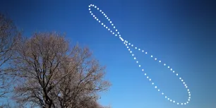
Due to Earth's tilted axis and slightly elliptical orbit, the Sun is never seen in the same position at noon in Tikota. Throughout the year, it slowly traces this figure-eight:
Move along the curve to read the Sun's altitude and azimuth for any day of the year in Tikota.
Over the year, the 12:00 Sun swings between just 49.2° above the horizon (around Dec 23) and 84.1° (around May 9) in Tikota. The smaller loop sits at the top, the signature of a Northern Hemisphere analemma. Notice the whole figure leans east of the meridian: over Tikota the Sun reaches its highest point between 12:11 and 12:42 depending on the time of year, but never at 12:00.
Detailed Analemma Chart
The technical chart below plots one dot per day, labels the first day of each month, marks the solstices, equinoxes, perihelion and aphelion, and draws the noon altitude of the equinoxes (90° minus your latitude) together with its ±23.4° seasonal limits.

Why does the figure look wider here than in the sky view above?
Both draw the same data, but with different conventions. The sky view uses the same scale on both axes, so it shows the analemma with its true proportions, as a camera would capture it: about 47° tall and only a few degrees wide. This chart, like most technical analemma diagrams, stretches each axis independently to fill the plot, expanding the narrow azimuth range several times so its day-to-day variation can actually be read. Also, azimuth is not sky distance: near the zenith, one degree of azimuth spans much less than one degree across the sky, which further widens the figure in this representation.
Places near Tikota, Karnataka
These nearby towns and cities have almost the same sunrise and sunset times as Tikota, Karnataka — the difference is only seconds to a couple of minutes. Select any place to see its own sun calendar:
Honwad 11 kmBijjargi 12 kmGote 16 kmKanamadi 18 kmTelsang 20 kmBobleshwar 20 kmArakeri 20 kmTikondi 22 km
 Eswatini
 Lesotho
 Puerto Rico